Lived on-board Hadar

Thursday, November 10, 2011

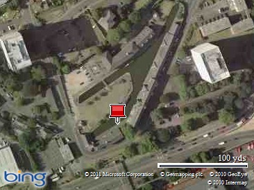
Coventry to Whitestone, Ashby Canal.

Map picture


Having had a great stay in Coventry, we set off for the Ashby canal this morning.

Ricoh Arena

We again passed the Ricoh Arena, home to Coventry City Football Club. the stand near the canalside is called the Tesco Stand, as there is a large Tesco’s very close to it, very handy if you need a supermarket in this vicinity, there are ringed moorings near Bridge No.8 which is the nearest access point to get to the supermarket.

We soon made Hawkesbury Junction, good thing we emptied our toilet cassette at Coventry Basin before setting off as someone was moored at the sanitary station, with no sign of anyone around!

I only took a small chunk of concrete out of the wall whilst turning at Marston junction to travel up the Ashby canal, which we haven’t been on since our first year on Hadar in 2008. There was enough space for us to pull into the 48hr moorings at Bridge No.5 and enough deep water.

Whitestone

Time to explore the area after lunch as we have never been here before. Note from the photo the unusual brick walling to the towpath moorings.

Keith.

Wednesday, November 09, 2011

Coventry City

We spent a whole 6 hours today in Coventry. As promised yesterday here is a photo of Coventry market. It is circular and as can be seen part of the purpose built rooftop car parking in Coventry is on top of the market building. This car park is linked to other buildings close by in an experiment to provide city centre car parking without taking up additional ground space, whilst utilising an area which serves no other purpose.

 SAM_0788

We did most of our shopping before lunch, not that we had a lot to get. Jo upgraded her T-Mobile dongle so she has superfast internet now!

SAM_0792

This building which is close to the Cathedral amazingly survived the incendiary bombs on November 14th 1940, unlike many of the buildings in the City centre.

SAM_0797

this is the old cathedral which was destroyed on that night.

SAM_0801

And this is the new cathedral, the building of which started in 1956 and was completed in 1962. My first visit to the cathedral was soon after it was opened in 1962.

SAM_0800

Amazingly the tower of the old cathedral survived the attack, despite the destruction of the rest of the building. A lot of restoration work has been carried out on the stonework, and further work is in progress.

We then visited the new Herbert Museum, with free entry always worth a visit.

SAM_0803

SAM_0807

This is the face of the civic building.

SAM_0810

This pub, The Golden Cross, also survived the bombing.

We had an excellent lunch at the Red Panda Chinese Buffet, yet another one to add to our list.

Then we visited the Coventry Transport Museum. We had visited it before but this time there was lots more to see this time.

SAM_0825

All sorts of transport, including this very early caravan.

SAM_0828

A section on racing cars.

SAM_0820

And a lot of vintage cars of all shapes and sizes, but all of the types of cars built in and around Coventry, along with motorbikes and bicycles.

SAM_0813

This is the bus that carried the Coventry City Football Club players through the City when they won the FA Cup in 1987.

SAM_0823

Even Monty’s staff car.

SAM_0830

This is the entrance to the Transport Museum.

SAM_0811

This structure is in front of the Transport Museum.

There is such a lot to see in Coventry, that 2 days mat be required for a first visit.

SAM_0834

And to finish, this is Hadar moored in the basin.

Keith.

Tuesday, November 08, 2011

Grimes Bridge, to Coventry.

Map picture


Coventry Basin 2

Drizzly start again this morning. We passed nb Chance soon after setting off, apparently Jo follows their blog. We arrived at Sutton Stop and one through the lock pulled in at the sanitary station to empty out. Soon after setting off from here we met Roy and his whippet Thomas off of Gerald No.13 walking along the towpath back to the boat which was moored at the junction, apparently.

Jo and I haven’t been to the basin in Coventry for over 6 years, when we first moved onto Misty Lady, and failed to make the lock closure at Atherstone, after buying Misty Lady from ABNB at Crick. We missed the stoppage date by 1 day, so had to hang around waiting for the stoppage to finish, before continuing our journey to Roger Fuller’s boatyard in Stone. Not much has changed on route, apart from the Ricoh Arena being finished, it was still being built in 2005 and a few new housing estates have popped up. Although some of the units here at the basin are empty, there are more being used than when we we last here, which is good.

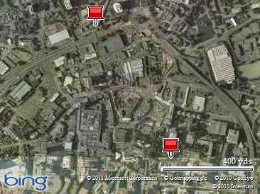
For those who have never been to Coventry by canal, this map below shows how close the basin is to the city centre, with the Cathedral marked with the lower pin.


Map picture

Tomorrow we will venture into the city which we have been looking forward to since we decided to come here this trip. We especially like the market in Coventry, I will try to get some photos of it for the blog tomorrow. The first time I ever came to Coventry was back in the 1962, soon after the new Cathedral was opened. My father’s job called for him to occasionally work in Coventry, and on this occasion he took us as well by car and dropped us in the city centre whilst he went to do some work, then picked us up when he had finished. I remember being bought a model of a MK10 Jaguar in the market. I couldn’t see one like it for sale in 2005 when we were last here!

Keith.

Monday, November 07, 2011

Newbold to Grimes Bridge No.26

Grimes Bridge

A dull morning with very low cloud, making very fine drizzle. We moved to the other side of Bridge 50 to take on water. Whilst here I walked down alongside “The Barley Mow”, to “The Boat” to take a few photos to indicate the original route of the Oxford Canal.

SAM_0754

This is the car park and beer garden opposite the entrance to “The Boat”, the grassed area where the benches are is part of the old route, as it lies very horizontal.

SAM_0755

This is the view from outside “The Boat” towards the existing canal. The building to the right is “The Barley Mow”, the one in the centre is “The Old Coach House” and the one on the left is what looks to be a warehouse. The route of the old canal would have passed to the left of this building in this photo.

SAM_0756

This is the end of the warehouse as viewed from the canal, the path of the old canal would have passed this building to the right of the picture.

SAM_0757

This view is where presumably the old canal passed the warehouse on this side of it.

SAM_0758

Finally this is the side of the warehouse that would have been alongside the old canal.

Mike Todd has passed onto me via this blog a very useful webpage which has old canal routes marked on it overlaid on the existing routes, which is very useful, and many thanks to Mike for passing that on. I still need to buy a modern map and then find old maps in a library to transfer the routes more accurately for further exploration, it is quite a challenge to see if it is possible to find these old maps and I am looking forward to it. Makes life on the canal during the winter months more interesting.

Once the water tank was full, we set off for a shortish journey to Grimes Bridge No.26, where we have for the first time in passing here found enough space and deep water for Hadar to moor in. Although previously we have always moved between Hawkesbury and Rugby, and vice versa in one day, it makes a pleasant change to be able to break the journey up.

Keith.

Saturday, November 05, 2011

Newbold-on-Avon’s Lost Canal

Yesterday I mentioned in this blog about discovering the lost sections of the North Oxford Canal, having discovered on-line about the original Newbold tunnel beside the church.

This morning Jo and I walked back to the church to start looking for it. The western portal is easy to find.

SAM_0734

This is the western portal alongside the church.

SAM_0730

Apart from being slightly overgrown it is in very good condition externally.

SAM_0732

This is the view through one of the two bat holes, not a brilliant photo, but you can actually see the tunnel walls for as far as the flash would illuminate.

SAM_0735

We then decided to see how far we could trace the line of the canal westwards. This photo is taken from the footpath that starts from within the churchyard, and the tunnel portal can clearly be seen between the church and the rather large oak tree.

SAM_0736

This is the view in the opposite direction from the footpath, showing clearly the dip in the field of the old canal.

SAM_0737

We started to follow the line of the old canal, which disappeared into a wooded area alongside the field, but through the wooded area, we spotted this wall, which could have been a wharf or canalside building.

SAM_0740

Further along we crossed over the line of the old canal over a small bridge, and were able to climb down into the canal bed where the brick wall was. However we did find the gratings in the wall rather perplexing as to what they were for.

SAM_0738

This is the footbridge we crossed over for access into the canal bed, although not an original bridge, it is sited where an original had been, as can be seen by the original stop plank slots in the existing wall, so common at bridge ‘oles.

SAM_0744

We walked further along and came across this original bridge still in very good condition with a road passing over it.

SAM_0745

This photo was taken in the opposite direction, the line of the canal can be clearly seen, despite natures best effort to hide it. We could not follow the line any further without some form of map to go by, so we returned back to the canal. We will have to return another day with a map to follow.

The eastern portal of the old tunnel is completely lost. As referred to on the website for the church, you can clearly see the dip in the churchyard entrance from the road to the church where the canal  tunnel collapsed in the exceptionally dry summer of 1976. The route of the canal from the church to the the existing canal is also unclear, as from the dip in the churchyard it is lost, presumably underneath the road. However the line can be traced opposite “The Boat” and “The Barley Mow” pubs. In front of “The Barlow Mow” is a large building next to the “Coach House” which looks like a converted wharf warehouse, and the canal would have passed the other side of this to join the existing canal in the vicinity of the water point.

SAM_0747

We then walked through the new Newbold Tunnel to see if we could trace the old canal from it’s other end.

SAM_0748

This is the other end of the old canal taken from the wrought iron bridge which takes the towpath over the entrance.

SAM_0749

This is the wrought iron bridge as viewed from the line of the old canal.

SAM_0750

Unfortunately further access is restricted, this photo being as far as we could proceed. Again we can further explore it if we have a map and can find further possible access points from the roads that cross the line.

We have enjoyed this little adventure. We will have to buy a decent scale map or maps, and then see if we can access old maps in a local library, either in Coventry or Rugby, and if we can, then mark on the new map the lines of all the old loops that have been lost on this canal. This should make it easier to do some more exploring.

Keith.

Friday, November 04, 2011

Rugby to Newbold-on-Avon

Newbold

It was rather nice to hear the overnight rain pounding on the cabin top, even if it did keep me awake! We just hope it also rained where the reservoirs are. We were in no hurry to set off, as we were not moving too far, so we waited for the rain to stop and then we set off. Not too far was an understatement really, 1.3miles which took all of 35minutes. We moored up before Bridge 50 at Newbold. With plenty of time before lunch we put our walking boots on, took our cameras and headed back down the towpath to Newbold Quarry Park.

SAM_0713

SAM_0715

SAM_0719

SAM_0726

The resident family of swans were giving us a great show of searching for food with tails up in the air.

After lunch we walked into Newbold, the church, St Botolph’s is very pretty.

SAM_0729

SAM_0728

The war memorial says it all really, it is always very sad to read the villager’s names who lost their lives, especially in the Great War, as so many of them were from the same family and probably brothers. Having returned to the boat Jo has discovered that the original canal course runs alongside the church, with the western portal of the original tunnel west of the church. We will have to return there over the weekend and have a further explore.

Map picture


One project I have is to trace all the lost sections of the original North Oxford Canal, which were the long contour loops which were replaced when the Oxford Canal Company decided to remove these winding loops in the late 1820’s and built new straight sections to reduce the overall length of the canal by some 14 miles of the original 36 miles between Braunston and Hawkesbury, to reduce journey times in competition with the newer Grand Junction, Warwick & Napton and Warwick & Birmingham canals.

Some of these newer sections are quite obviously straight which is very unlike the Oxford canal. Another factor is the wider bridges that cross these newer sections of canal, some of which are wrought iron, as used in the early 1800’s, similar to those that Telford used when he built his newer Birmingham Canal.

Keith.

Thursday, November 03, 2011

Hillmorton to Rugby

Rugby

With the prospect of rain this afternoon, if the forecast is to believed, we set off down through Hillmorton locks and headed towards Rugby. We noticed a new section of piling that earlier in the year we had seen being installed, and now makes a nice mooring midway between Hillmorton and Rugby. I pulled in to the bank at Boughton Road Bridge, and Jo walked ahead to Broughton Park, to see if there was room for us to moor. We have a system where if it is ok Jo rings my phone, but I don’t answer it, so it doesn’t cost anything. I set off and joined her at the park, and we moored up next to Maffi. We had a quick chat, as you do, and then we set off to Tesco’s for shopping.

After lunch I have to go to Halfords to get a replacement radio aerial, if they have a suitable one in stock.

Keith.